

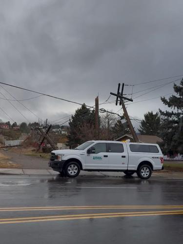
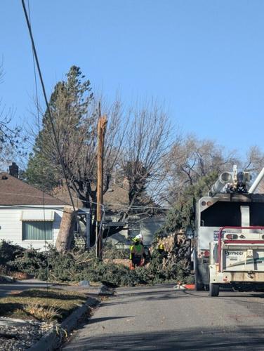
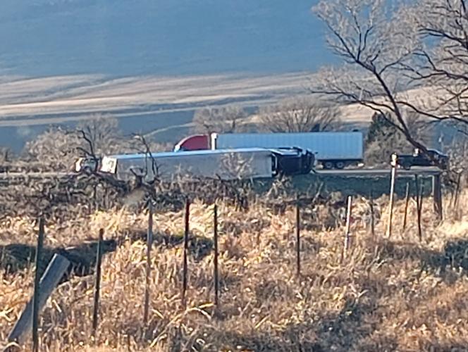
A powerful windstorm swept through East Idaho and much of the Pacific Northwest on Wednesday, overturning semitrailers, uprooting trees and downing power lines.
Dawn Harmon, a senior meteorologist with the National Weather Service in Pocatello, said forecasters had been tracking the system since last weekend. After growing probabilities predicted extremely strong winds and widespread gusts exceeding 60 mph, the weather service issued a high wind watch Monday before upgrading it to a high wind warning Tuesday.
Winds as powerful as a Category 1 hurricane swept through areas like Sheep Creek Hills near Bear Lake, peaking at 86 mph, according to reports from the National Weather Service. Pocatello saw peak gusts around 69 mph, while fast-moving morning thunderstorms pushed wind speeds in some areas like Fort Hall and Aberdeen to more than 75 mph.
“Instantaneous gusts of 80 miles an hour are going to be dangerous to any kind of vehicle on the roadway, not just the semis,” Harmon said.
While Harmon could not comment on the historic nature of the storm compared to past years, she said what made this event stand out was the sheer geographic reach that included the entirety of the Pacific Northwest and Northern Rockies.
The tempest produced numerous reports statewide to law enforcement agencies that included damage to residential and commercial property, interstate blockages, power lines and pockets of power outages in areas including historic downtown Pocatello.
The chaos prompted safety warnings from state and local police, and the litany of overturned semitrucks resulted in interstate lane closures and blockages.

Pocatello crews worked with local businesses and organizations to address the damages from Wednesday’s windstorm.
Between approximately 12:30 p.m. and 4 p.m. Wednesday, emergency responders handled 11 separate incidents involving high winds and large vehicles, including several semis and a fifth-wheel trailer, according to an Idaho State Police news release issued Wednesday.
In one of the initially reported crashes, a semi was blown sideways across Interstate 15 near the Flags West truck stop in Downey, causing full blockage and forcing traffic to be diverted near Devil’s Creek Reservoir.
Additional incidents followed, including a southbound truck that tipped over on I-15 and fully blocked the left lane. Recovery crews had to pull the vehicle out of the roadway to reopen traffic.
Two other semis were blown over after pulling off on an embankment near the Highway 44 southbound off-ramp, creating a full ramp closure. On the northbound off-ramp, a fifth-wheel trailer flipped and another semi crashed, prompting officials to shut down the southbound 44 off-ramp for hours.
Recovery efforts ramped up around 8 p.m., but high gusts complicated operations.
“The wreckers were concerned that if they flipped those back up at that point that they were just going to get blown right back over,” said Idaho State Police Lt. Todd Orr.
By Thursday morning, Orr said all overturned semis had been removed, with only one enclosed trailer still awaiting recovery. Orr also said high-profile vehicles like semis and fifth wheels are especially vulnerable in strong winds, noting some of the semi drivers who pulled off onto ramps were hit harder when wind funneled through nearby valleys and up embankments, toppling their rigs. Orr said the more experienced drivers sought shelter on the sides of hills or directly under bridges.
“Welcome to winter in Idaho,” Orr said. “We have an impending snowstorm right now, so everybody make sure their vehicles are as they should be.”
Orr advised standard practices for Idahoans enduring the inclement winter weather — full gas tanks, proper tires, wearing seat belts, carrying blankets and car chargers and expecting potential delays while traveling.

Overturned semi-trucks near the Jensen Road exit in McCammon.
The storm also sheared off multiple highway and exit signs. The signs are designed with breakaway features so they fall rather than snap rigidly under extreme wind loads. The Idaho Transportation Department is aware of the damaged signs and plans to restore them in coming weeks as conditions allow.
“If you don’t need to be out traveling in a snowstorm or a windstorm, don’t,” Orr said. “Use your best judgment. Next week, we got a lot of ‘over the river and through the woods to Grandma’s house’ for Christmas and seeing family. If it’s safe to do so, great. But if it’s not, really consider waiting an hour until the roads get cleaned up, that kind of thing.”
Locally, city officials and staff raced to clear fallen trees and debris from public green spaces, closing the city cemetery due to the danger of the shifting tree canopy, said Anne Butler, parks and recreation director.
Butler estimates seven or eight trees were lost around town, including a pair of large spruces near City Hall. Crews focused first on hazardous spots and key access routes, then moved into parks and green spaces. Butler said the most obvious hazards and road blockages have been cleared, with remaining cleanup in parks expected to wrap up well before Christmas.
The city has provided a space to collect firewood from the recently downed trees at Lower Ross Park, across from the baseball fields. Anyone interested in the free firewood must load it themselves and sign in with a provided QR code nearby to obtain a permit. For safety reasons, the use of chainsaws in the area is prohibited.
Harmon forecasts another front to move through Friday, bringing wind advisory-level conditions to Pocatello, Idaho Falls, Rexburg and the Idaho National Laboratory area. Harmon predicts sustained winds of 25 mph to 35 mph and gusts exceeding 40 mph, though winds are not expected to reach Wednesday’s extremes.
Harmon said the National Weather Service anticipates unsettled conditions through Christmas, with periods of rain in the valleys and snow mainly in the mountains and overpasses.
The National Weather Service is still accepting reports of significant damage from Wednesday’s storm, especially to homes and major property. Residents can submit information and photos via the National Weather Service Pocatello Facebook page to help further refine local storm reports.

(0) comments
Welcome to the discussion.
Log In