

On Oct. 14, 1965, Blackfoot City Councilman Wally Moses announced his intention to give up his seat and not run for re-election. He had been serving for five years. As one of his final acts in his current term, Moses and Councilman Robert (Bob) Bishop met with Arnold and Gertrude Jensen to finalize the sale of a large chunk of their farm to the city to be used for recreational facilities. A photo of the signing ceremony appeared in the Blackfoot News the next day. This transfer gave the city control of a continuous strip of land from the freeway exchange north, along the east side of the freeway, to the golf course, and east to the Airport Park area. Since the land was a wooded area, it was believed it would take minimal landscaping to become a city park.
Arnold and Gertrude Jensen lived in a two-story brick house that is still at 625 N. Meridian. Their original 100-acre farm had been inherited from Arnold’s father. When the freeway was built, it split the farm in two and caused the river to be rerouted to the west side of the freeway. The Jensen Grove Lake is part of the old river channel. (The fact that the river is no longer in its original channel will become an important part of my next story.)
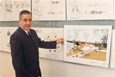
City officials began immediately working with the Architecture Department at Idaho State University. Fifth-year students with an advisor would work on a plan and present it to the city and the Chamber of Commerce. The project was accepted by ISU before the end of October, and the students had made a visit to Blackfoot, walking the entire area with Dr. A.E. Miller and Bud Packham as guides. Partnering with the Architecture Department was a valuable two-way experience, allowing students nearing graduation to demonstrate their talents in a real-world situation, and for civic leaders to work with future community planners to come up with an exciting design without cost to the city. An official proposal booklet was written, and a large-scale model was built by the students and displayed in the university’s Fine Art Center.
These were the original requirements:
1. Maximum usage of land and water for all types of outdoor recreation for year-round use.
2. Expansion of the current nine-hole golf course to an 18-hole green with associated clubhouse. (Funded privately.)
3. Development of the current air strip to provide for hangar and tie-down areas. (Funded privately.)
4. Necessary presentations to city political units, social, business and religious groups.
5. Necessary application for matching funds as a result of city approval.
By February of 1966, a preliminary concept was completed and presented to the city of Blackfoot. By April, city-wide support was secured and an application for federal matching funds had been submitted. With the advent of spring weather, volunteer groups worked to clean debris from the wooded area, and damaged or unhealthy trees were removed. Federal funding delays caused the work to slow over the summer, though the private donation fund was growing. The Architectural Department concept stated that it would take 10 years to complete the project, and the total cost was estimated at $282,426, of which half was scheduled to come from federal funds.
The amphitheater was part of the original plan as a landmark for the park. Viewed from the freeway, across the water, it is a stunning and unexpected addition to the park layout. A 700-foot beach was included. The plan called for 200 individual picnic units. We don’t have that many, but what we have seems adequate. The large picnic shelter with two fireplaces was not in the plan, but is much appreciated and well-used summer and winter.
There were to be shelter spaces and latrine facilities, which we have. The playground equipment has been upgraded far beyond the 1966 standards, and the parking areas for cars look to be much improved from the plan.
Also, not in the original plan are the walking/biking trails around the wooden area and around the entire lake, which is a wonderful and well-used addition, especially since the northern part has been extended all the way to Rose Pond. The lake itself seems smaller than the plan allowed for, but is perfectly usable for boating, waterskiing and jet skiing. The airport is larger than in the plan. They needed the extra room for a longer runway, which was a good choice for the city. The golf course got its second nine holes. The skateboard park was not even a “thing” in 1966, but it fits in very well.
What the students planned that we did not get were horseback riding facilities, model airplane and model boating spots, the ability to canoe into the slough, a Boy Scout retreat, a spot for overnight camping, a formal garden and a large sports complex. All of these things (except the canoeing) were planned for the unused area to the north of the boat ramp along the walking trail. But the sports complex and a trailer camping area have ended up at the Airport Park, which is actually better from a space and parking point of view. All the rest seems like extra fluff at this time.
The students involved were Larry McKay, Perry Kiai, Manuel V. Munoz, Bruce Nelson and Tom Huntington, under the supervision of Professor R.P Fasoline. I hope they went on to do great things in their chosen field, and I would bet that Arnold and Gertrude Jensen would be proud of what has been done with their land.


(0) comments
Welcome to the discussion.
Log In