

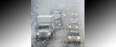

Submitted photo
By Journal Staff
Multiple winter weather advisories have been issued for East Idaho, with more than 10 inches of snow expected in some higher elevation areas.
Though a winter weather advisory has not been issued for Pocatello as of 6 p.m. Thursday, the National Weather Service did say that the Gate City area would likely get some precipitation on Friday. However, it would likely be rain or a mixture of rain or snow due to above freezing temperatures.
It’s a different story further north in Idaho Falls, Rexburg and the Idaho National Laboratory, where 1 to 4 inches of snow is expected. A winter weather advisory for those areas is scheduled for Friday from 5 a.m. to 5 p.m.
The winter weather advisory says:
* WHAT…Snow expected. Plan on slippery road conditions, including during the morning commute on Friday. Total snow accumulations of 1 to 4 inches are expected. Some blowing and drifting of snow will also be possible.
* WHERE…The Upper Snake River Plain, including the INL, Idaho Falls and Rexburg.
* WHEN…From 5 AM to 5 PM MST Friday.
* ADDITIONAL DETAILS…Be prepared for reduced visibilities at times.
*******
A winter weather advisory will also be in effect from 5 a.m. to 5 p.m. Friday for Georgetown, Henry, Lava Hot Springs, Montpelier, Palisades, Pebble Creek, Pomerelle and Soda Springs.
This winter weather advisory says:
* WHAT…Snow and blowing snow expected. Plan on slippery road conditions, including during the evening commute on Friday. In addition, areas of poor visibility are expected. Total snow accumulations of 3 to 5 inches, with localized amounts up to 11 inches, are expected.
* WHERE…Henry, Soda Springs, Montpelier, Lava Hot Springs, Pomerelle, Pebble Creek, Georgetown, Palisades.
* WHEN…From 5 AM Friday to 5 AM MST Saturday.
* ADDITIONAL DETAILS…Winds gusting as high as 40 mph will cause areas of blowing and drifting snow, especially over mountain passes.
*******
A winter weather advisory will begin 11 p.m. Thursday and will run until 11 p.m. Friday for St. Anthony, Ashton, Driggs, Island Park, Monida Pass and Victor. According to the National Weather Service, accumulations of 6 to 10 inches is expected, with localized amounts up to 14 inches. Forecasters said to be prepared for reduced visibilities.
*******
A winter weather advisory is already in effect for the cities of Arco, Challis and Mackay, where snow accumulations of 4 to 8 inches are expected, with higher elevation amounts up to 12 inches in the forecast.

(0) comments
Welcome to the discussion.
Log In