


Doug Lindley/Idaho State Journal
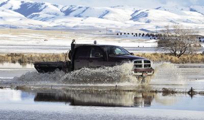
A pickup drives through high water on the Cold Water Road that runs next to Interstate 86 in the Raft River area.
Update
THE NATIONAL WEATHER SERVICE IN POCATELLO HAS ISSUED A * FLOOD WARNING FOR THE PORTNEUF RIVER AT POCATELLO. * FROM FRIDAY AFTERNOON TO SUNDAY AFTERNOON… OR UNTIL THE WARNING IS CANCELLED. * AT 11:45 AM THURSDAY THE STAGE WAS 6.4 FEET. * FLOOD STAGE IS 8.5 FEET. THE PORTNEUF RIVER AT POCATELLO IS FORECAST TO REACH FLOOD STAGE 11:00 AM MST FRIDAY AND PEAK NEAR 9.1 FEET ABOUT 12:00 PM MST SATURDAY. * MINOR FLOODING IS FORECAST. * IMPACT… AT 9.1 FEET… FLOODING OF LOW LYING AGRICULTURAL LAND AND PASTURE WILL OCCUR IN THE INKOM AND BLACKROCK AREA. LOWLAND FLOODING IS LIKELY ALONG SECTIONS OF THE RIVER BETWEEN PORTNEUF GAP AND THE CHEYENNE AVENUE BRIDGE IN POCATELLO.
… THE NATIONAL WEATHER SERVICE IN POCATELLO HAS ISSUED A FLOOD WARNING FOR THE FOLLOWING RIVERS IN IDAHO… PORTNEUF RIVER AT POCATELLO AFFECTING BANNOCK COUNTY . RECENT WARM TEMPERATURES AND RAIN FALLING ON SNOW HAVE INCREASED THE RUNOFF INTO THE PORTNEUF RIVER AT POCATELLO. THE RIVER IS EXPECTED TO REACH FLOOD STAGE NEAR 11:00 AM MST FRIDAY. MINOR FLOODING IS FORECAST FOR LOW LYING AGRICULTURAL LAND AND PASTURE BETWEEN INKOM AND BLACKROCK. LOWLAND FLOODING IS ALSO LIKELY ALONG SECTIONS OF THE RIVER BETWEEN THE PORTNEUF GAP AND THE CHEYENNE AVENUE BRIDGE IN POCATELLO. PRECAUTIONARY/PREPAREDNESS ACTIONS… SAFETY MESSAGE… PERSONS NEAR THE RIVER SHOULD BE AWARE OF THE EXPECTED HIGH WATER AND TAKE ACTION TO PROTECT PROPERTY OR LIVESTOCK.
Original story
By Kendra Evensen, kevensen@journalnet.com
Officials with the National Weather Service forecast office in Pocatello say even more nuisance flooding could occur in Southeast Idaho over the next few days, and they are encouraging people who have been affected by flooding in the past to be prepared.
Warmer temperatures and rain are melting the significant snowpack in mid- to low elevations, and a moist storm system moving through the region Thursday could make the problem worse.
Meteorologist Mike Huston said the Portneuf River in the Pocatello area, which is currently about 5.87 feet deep, could reach 9.48 feet by Saturday morning.
That means sections of Sacajawea Park could be under water, and Marsh Creek near Inkom may also overflow its banks, according to the National Weather Service website.
In addition, flooding could occur in low-lying agricultural land in the Inkom and Blackrock area and along sections of the river between Portneuf Gap and the Cheyenne Avenue Bridge in Pocatello. Water could also reach some benches near the river at the Pacific Recycling Trailhead.
Weather officials have issued a flood watch because of the potential for increased flows.
“Flooding is possible on low-lying areas along the Portneuf River,” the flood watch states. “Those with property or livestock interests along the river should stay current on water levels and consider any actions to protect those interests.”
“Another very moist storm system will cross Southeastern Idaho Wednesday night and Thursday,” according to the advisory, which will be in effect until noon on Saturday. “Snow levels will rise to near 8,000 feet elevation by Thursday afternoon, therefore the middle and lower slopes will see rain falling on snow packs. This will increase the rate of snow melt and runoff, making the situation worse especially for areas where flooding is already occurring.”
As part of the advisory, weather officials are reminding people not to cross flooded roads. And there are some of those around. A large section of Interstate 86 west of American Falls has been closed since Monday because of surface water, and Huston said there has been a report of water on Highway 81, south of Malta, a city in Cassia County as well.
Huston said Cassia and Minidoka counties have been hit the hardest by snowmelt flooding, but other areas could see similar problems in the days ahead.
He encourages homeowners to clear snow away from their houses and make sure basement drains — and others in and around their home — are clear and can shed water. Those who’ve had flooding problems in the past may also want to pick up a pump just to be prepared, he said.
Pocatello did set a new daily maximum record for rainfall on Tuesday with 0.73 of an inch. That beat the old Feb. 7 record of 0.57 that was set in 2004, according to weather officials.
The city also saw a temperature high of 45 on Wednesday, which isn’t record-breaking but is still about 10 degrees above average, Huston said. And he thinks it could get even warmer on Thursday.
Huston said the temperatures should start cooling off around Friday, which should help with flooding issues.
“We’ll start to see a little reprieve into the weekend.” he said.

(0) comments
Welcome to the discussion.
Log In