

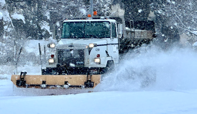
A major winter storm is forecast to bring several inches of snow and destructive winds to East Idaho Tuesday morning through Wednesday afternoon.
The National Weather Service has issued winter storm warnings and winter weather advisories for East Idaho to warn the public about the very hazardous road conditions the winter weather will create.
The storm is forecast to dump several inches of snow on even lower elevation areas in East Idaho as well as bring winds of up to 60 mph to the region.
The weather service said that “travel could be very difficult to impossible” in East Idaho during the storm, blowing snow could result in near-zero visibility and the powerful winds could be strong enough to bring down tree branches.
“If you must travel, keep an extra flashlight, food and water in your vehicle in case of an emergency,” the weather service advised.
The areas expected to receive the most snow from the storm — up to 10 inches Tuesday morning through Wednesday afternoon — are Arbon, Inkom, McCammon, Arimo, Downey, Lava Hot Springs and Emigration Summit.
As much as 6 to 8 inches of snow could fall on the Albion, Almo, Malta, Rockland, Holbrook, Grace, Bancroft, Soda Springs, Henry, Bone, Wayan, Swan Valley, Palisades, Victor, Ashton, Tetonia, Driggs, Island Park, Malad, Preston, Thatcher, Burley, Rupert, Heyburn, Oakley, Raft River, Declo, St. Charles, Montpelier, Paris, Georgetown, Mud Lake, Idaho National Laboratory, Atomic City, Craters of the Moon, Idaho Falls, Ammon, Rigby, Rexburg and St. Anthony areas.
Up to 4 or 5 inches of snow are expected to fall on the Dubois, Spencer, Arco, Pocatello, Chubbuck, American Falls, Aberdeen, Blackfoot, Fort Hall, Firth and Shelley areas.
East Idaho’s higher mountains could receive as much as 20 inches of snow from the storm.
The storm has triggered winter storm warnings, winter weather advisories and even some blizzard warnings throughout the rest of Idaho.
Severe winter weather warnings are also in effect in all of the states surrounding Idaho because of the storm.

(0) comments
Welcome to the discussion.
Log In