

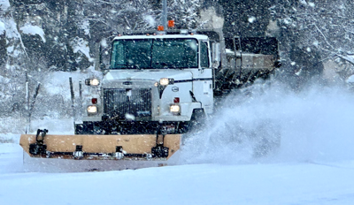
The National Weather Service has declared winter storm warnings for parts of East Idaho as snow from a Thanksgiving storm continues to fall on the region.
The storm arrived in East Idaho on Thursday morning and is forecast to continue dumping snow through Friday morning.
A winter storm warning is now in effect for the Declo, Raft River, Burley, Rupert, Albion, Oakley, Heyburn and Almo areas calling for up to 10 inches of snow in the lowlands and up to 14 inches of snow in the mountains.
A winter storm warning is also in effect for the Emigration Summit area of Bear Lake County where up to 16 inches of snow is expected to fall.
The weather service said the storm is creating "very difficult" driving conditions in East Idaho and drivers should use caution and slow down because local roads are hazardous.
If you do plan to drive anywhere during the storm in East Idaho, expect blowing and drifting snow fueled by winds of up to 40 mph. The gusts will be strong enough to bring down tree branches.
The weather service is advising motorists to make sure to have emergency supplies in their vehicles such as flashlights, blankets, food and water in case of an emergency.
Winter weather advisories are in effect in those areas of East Idaho not under winter storm warnings.
The Malta, Rockland, Holbrook, Arbon, Inkom, Arimo, McCammon, Downey, Lava Hot Springs, Grace, Bancroft, Soda Springs, Henry, Bone, Wayan, Palisades and Swan Valley areas could receive up to 5 inches of snow from the storm in the lowlands and as much as 10 to 15 inches of snow in the mountains.
The Victor, Ashton, Tetonia, Driggs, Island Park, Dubois and Spencer areas could receive up to 3 inches of snow in the lowlands and up to 9 inches of snow in the mountains.
The Malad, Preston, Thatcher, St. Charles, Montpelier, Paris, Georgetown, Mud Lake, Idaho National Laboratory, Craters of the Moon, Idaho Falls, Ammon, Rexburg, Rigby, St. Anthony, Pocatello, Chubbuck, Blackfoot, Aberdeen, American Falls, Shelley, Firth and Fort Hall areas could receive up to 4 inches of snow from the storm.
Elsewhere in the state, winter weather advisories and winter storm warnings calling for several inches of snow are in effect in the central Idaho mountains including Hailey, Sun Valley, Ketchum, Stanley, Challis, Mackay, Salmon and Arco, in south central Idaho including Twin Falls and Jerome, and in southwest Idaho including Boise and Mountain Home.
Outside of Idaho, winter weather advisories and winter storm warnings are in effect in Nevada, Utah, Montana and Wyoming because of the storm.
Stay with idahostatejournal.com for the latest weather forecast updates.

(0) comments
Welcome to the discussion.
Log In