

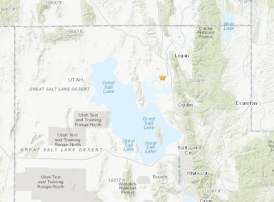
A minor earthquake centered in southern Box Elder County, Utah, awoke some northern Utah residents from their Saturday morning slumber, but wasn’t strong enough to do any significant damage.
The U.S. Geological Survey and University of Utah Seismograph Stations reported the 3.6-magnitude quake happened at 6:45 a.m. Saturday, Nov. 12. Sensors pegged the epicenter at a spot 4.5 miles southwest of Corinne, along the southernmost portion of Iowa String Road (6800 West).
According to the University of Utah Seismograph Stations, more than 100 people from Salt Lake City to Logan reported feeling the quake shortly after it happened.
There have been numerous smaller quakes within less than a mile of Saturday’s temblor since Nov. 2, ranging from 1.1 to 2.7 in magnitude — generally not strong enough to be felt on the surface.
According to the USGS, the area is part of the Intermountain seismic belt, a prominent north-south-trending zone that includes the Wasatch Front urban corridor.
A modern catalog of instrumentally located earthquakes in Utah begins in mid-1962, and historical earthquake records date back to the 1850s. In general, earthquakes measuring 5.0 or higher on the Richter scale occur at an average rate of about one every 10 years in the region, and 6.0 or larger about once every 50 years.
The largest historical earthquake on record in the area was a 6.6-magnitude surface-faulting event in the Hansel Valley of northern Box Elder County in 1934.
Anyone who felt the earthquake is encouraged to fill out a survey form on the US Geological Survey website at earthquake.usgs.gov. As of Monday morning, more than 300 people had filled out the form in response to Saturday’s event.


(0) comments
Welcome to the discussion.
Log In