



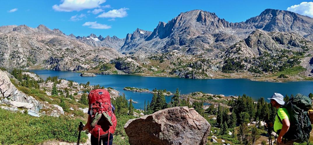
I was looking through my photos from last week’s Wind River Range backpacking trip and, though they were wonderful scenes of high alpine beauty, I thought they just didn’t capture the feeling of being there.
Several times my companions and I would hike into a mountain meadow or lake area surrounded by giant granite peaks — some more than 13,000 feet high– and pause to soak it in. “This place is amazing!” one of us would say. “Sure is,” another would concur, pulling out a camera to record the moment.
So we had two main goals while hiking for five days into the Wind River wilderness backcountry of Wyoming about two hours south of Jackson, Wyoming last week. We wanted to climb to the top of Fremont Peak (elevation 13,751 feet) — the third highest peak in Wyoming, surpassed only by Gannett Peak and the Grand Teton. Secondly, we wanted to explore some new territory and trails. Personally, I also wanted to catch a few fish to supplement my freeze-dried meals with something fresh.
The route to the base of Fremont Peak passes through some of the most popular trails in the Wind Rivers. We started out at the Elkhart Park Trailhead east of Pinedale, Wyoming. This trailhead sits at roughly 9,000 feet. You gain large chunks of elevation driving up in your car. In the large parking lot we saw vehicles from a dozen different states and Canadian provinces. Obviously this place is no secret.
We started on a Monday morning and saw dozens of hikers on the trail. Most seemed to be coming or going in the general direction we were headed: Island Lake and Titcomb Basin. Our first stop was Seneca Lake, about 9 miles in.
One thing I’ve learned about hiking in the Wind Rivers is to try to keep the hiking mileage to about 10 miles or so to keep my energy up — especially if I want to climb a mountain. The challenge comes from the altitude. Unless you have an acclimated body for the high country, the energy drains quickly. I start feeling it hit me at close to 10,700 feet. Seneca Lake sits at about 10,600 feet.
From Seneca Lake we hiked the next day to Indian Pass Basin past Island Lake and set up camp near the Lower Indian Pass Lake at 11,000 feet — about 5.5 miles. We then day-hiked into Titcomb Basin — 2 miles one way — to see the popular basin surrounded by towering spires of 12,000 and 13,000 foot peaks. Titcomb Basin and Indian Basin are above the treeline.
In retrospect it was probably tougher on our bodies to sleep at 11,000 feet. We generally felt a bit sluggish the next morning when we rose to climb to the top of Fremont Peak.
Fremont Peak is nearly 1,000 feet taller than Idaho’s Borah Peak which is at 12,662 feet, but you do get to start from a higher elevation. The distance may be shorter from base camp, but once you reach the base of the mountain, it’s steep and scrambly the entire way up. The slope is class 3+ (nothing technical, or too exposed) but can get hairy if you stray off route. It took us a bit over three hours to summit.
When we scrambled up to the summit, we found ourselves carefully peeking over the tippy top because the wind was howling at about 30 mph — no glory shots of headstands or backflips. Fremont Peak’s extra height did allow me to have cell phone coverage to make a call to my sweetheart.
On the northeast side of Fremont Peak is a sheer drop off perhaps 500 to 1,000 feet along the spine of the range. This east side has the largest glacier I’ve ever seen, actually several glaciers flowing into each other about 3 miles long. The sight made all the huffing and puffing to the top worth the effort.
After we climbed Fremont Peak, we hiked back to our camp in Indian Basin, rested a bit, gathered our camp and hiked to Island Lake a couple of miles away and a few hundred feet lower in elevation. Here we set up another camp. The loss in elevation was noticeable, adding some extra pep to our steps.
Island Lake proved to have some fat trout — so big, I had to cut them in half to fry them up in my small 8-inch pan.
The next morning we did an adventure hike along a route with an intermittent trail. We hiked southeast over a small pass to Wall Lake.
At Wall Lake, we met a pair of through-hikers from Bozeman, Montana, who started hiking in Yellowstone National Park and were on their way to Colorado.
From Wall Lake — still following an occasional trail — we hiked to Cook Lakes, where we eventually hooked into an actual trail and found our way to Pole Creek Lakes to camp after about 10 miles of walking. It was fun to cover new, beautiful territory.
From Pole Creek Lake, we hiked another 10ish miles back to Elkhart Park trailhead and our car. At that point, our main goal was tacos and milkshakes.
I have hiked many times in the Wind Rivers and on this trip I was struck by the in-your-face beauty, the great weather and lack of mosquitoes. I never once got out my bug repellent.


(0) comments
Welcome to the discussion.
Log In