

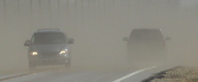
The National Weather Service has issued a high wind watch for most of East Idaho on Wednesday as a powerful cold front barrels through the region, bringing fierce winds that could gust up to 65 mph in some areas.
The watch is in effect from 5 a.m. to 5 p.m. Wednesday for numerous local communities including Pocatello, Chubbuck, Idaho Falls, Ammon, Blackfoot, Fort Hall, Shelley, Firth, Atomic City, Idaho National Laboratory, Craters of the Moon, Aberdeen, American Falls, Declo, Raft River, McCammon, Arimo, Downey, Inkom, Swan Lake, St. Anthony, Ashton, Rexburg, Rigby, Burley, Rupert, Soda Springs, Grace, Bancroft, Driggs, Victor, Tetonia, Malta, Rockland, Arbon and Lava Hot Springs.
Southwest to west winds are expected to reach sustained speeds of 25 to 35 mph with gusts between 60 and 65 mph, according to the weather service.
The strong winds pose a serious threat to high-profile vehicles and could cause isolated damage to trees, power lines, signs and outbuildings. Isolated power outages are possible and loose outdoor objects could become dangerous projectiles.
“Travel could be difficult, especially for high-profile vehicles,” the weather service warned.
The cold front will also bring rain to East Idaho’s lowlands and snow to the highlands, though precipitation amounts are expected to be light except above 7,000 feet, where 6 to 10 inches of snow could fall.
Snow levels will start around 7,000 to 8,000 feet late Tuesday night but will drop throughout Wednesday as the front passes through East Idaho.
The region’s higher mountain passes may experience severely reduced visibility from blowing and drifting snow, creating rapidly deteriorating and hazardous driving conditions.
Backcountry users should expect dangerous winter conditions as winds gusting over 60 mph combined with heavy snowfall at elevations above 7,000 feet could produce periods of blizzard conditions.
The weather service urges East Idahoans to monitor the latest forecasts and secure loose outdoor objects before the winds arrive. Drivers of high-profile vehicles should consider staying off local roads until Wednesday’s winds subside.
High wind watches and warnings have also been declared throughout most of the rest of Idaho as well as in Montana, Oregon, Washington state and Wyoming.
In addition, a winter storm watch has been declared in western Wyoming calling for up to a foot of snow late Tuesday night through Wednesday evening.

(0) comments
Welcome to the discussion.
Log In