

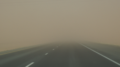
East Idaho's historic windstorm is delivering as promised, with the Idaho Transportation Department shutting down two lengthy stretches of Interstate 15 on Saturday as dangerous winds and blowing dust created very hazardous travel conditions across the region.
ITD closed a 26-mile stretch of I-15 from Idaho Falls north to Highway 33 and a five-mile stretch of I-15 south of Idaho Falls Saturday afternoon due to high winds and near-zero visibility. No reopening timeline has been announced.
The closures mirror what happened Thursday in East Idaho — and forecasters had warned that Saturday could be worse.
The destructive windstorm arrived in East Idaho on Thursday, shutting down nearly 30 miles of Interstate 15 and leaving many without power as gusts reached 70 mph. Saturday's round two proved equally punishing, with the National Weather Service warning that conditions remain "dangerous and possibly life-threatening" across all of East Idaho.
Saturday's threat is serious. Historic, even.
High wind warnings are in effect from 9 a.m. to 9 p.m. Saturday across East Idaho's lowlands, including the Pocatello, Chubbuck, Blackfoot, Fort Hall, American Falls, Aberdeen, Shelley, Firth, Idaho Falls, Ammon, Rigby, Rexburg, Burley and Rupert areas. Winds of 55 mph to 65 mph are expected throughout those areas — with hurricane-strength gusts of up to 75 mph possible.
A blowing dust warning runs from noon to 9 p.m. Saturday in the Idaho Falls, Ammon, Rigby, Rexburg, Sugar City and St. Anthony areas, with the National Weather Service warning that blowing dust will cause severely reduced visibility, especially along I-15 north of Idaho Falls.
Here's how rare that is: The last time a blowing dust warning was issued for East Idaho was April 23, 2020 — the only other such warning ever issued for the region. Saturday marks just the second time in recorded history that East Idaho has faced conditions dangerous enough to trigger one.
Wind advisories covering the remainder of East Idaho call for gusts of 40 mph to 50 mph Saturday morning through Saturday night.
The numbers are stark: There is a greater than 60% chance of gusts exceeding 55 mph along I-84, I-86, I-15 and Highway 20 Saturday — and a greater than 30% chance of gusts topping 50 mph across all of East Idaho. Winds are expected to peak between noon and 6 p.m. Saturday.
Strong crosswinds will make travel dangerous, particularly for high-profile vehicles.
The storm's arrival on Thursday gave East Idaho a brutal preview of what Saturday would bring. Zero-visibility dust storms triggered several wrecks, including a multi-vehicle crash that partially shut down I-15 south of Idaho Falls for three hours Thursday afternoon. Some of the wrecks resulted in injuries but further details haven't been released. By early Thursday evening the dust storms were so bad that the Idaho Transportation Department closed two stretches of Interstate 15 — a 24-mile section from Idaho Falls to the Sage Junction area and a five-mile stretch south of Idaho Falls. The closures lasted for several hours.
Thursday's strongest gusts — 70 mph — were reported at Craters of the Moon National Monument and in Idaho Falls, winds that can be considered near hurricane strength. Blackfoot recorded maximum gusts of 58 mph on Thursday while Pocatello reached 48 mph. Most of East Idaho saw winds over 50 mph Thursday that toppled trees, caused dust storms and downed power lines, knocking out electricity across the region.
With dangerous conditions continuing, the National Weather Service is urging residents to act now: Secure or bring inside all loose outdoor objects. Drivers of high-profile vehicles should strongly consider delaying all travel Saturday, especially between noon and 6 p.m. If you encounter blowing dust on the road — or see it approaching — pull off as far as possible, put the vehicle in park and turn all lights off. Do not press the brake pedal. Remember: "Pull Aside, Stay Alive."
Persons with respiratory problems should stay indoors until conditions improve.
Monitor Idaho 511 for the latest road conditions. This storm is far from over — and Saturday's round two may go down as among the worst East Idaho has ever seen.
Elsewhere in the state, high wind warnings and wind advisories are in effect in south central Idaho and southwest Idaho and winter weather advisories and avalanche warnings are in effect in North Idaho.
Wind and winter weather alerts are also in effect in all of the states surrounding Idaho.

(2) comments
Massive amount of oil is burning in the Middle East fires now. Plus the bombing continues every day. So a lot of energy is destabilizing our global climate system. And the waves are rolling in, reaching Pocatello.
Massive amount of oil is burning in the Middke East fires now. Plus the bombing continues every day. So a lot of energy is destabilizing our global climate system. And the waves are rolling in, reaching Pocatello.
Welcome to the discussion.
Log In