

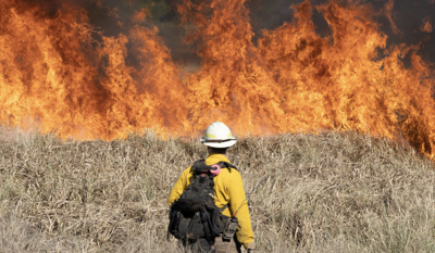
A wildfire that had already threatened homes near Massacre Rocks took a dramatic turn overnight — first appearing to shrink after improved mapping, then exploding past its previous size within hours, fire officials said Friday.
The Lake Channel Fire, sparked by lightning in Power County, was reported by a motorist driving on Interstate 86 who spotted the flames around 5:30 p.m. Wednesday, burning north of the freeway and the Snake River just west of Massacre Rocks, authorities said.
Early Thursday evening, the U.S. Wildland Fire Service revised its estimate of the fire’s size down from 2,000 acres to about 1,200 acres, saying more accurate mapping had shown the blaze was smaller than initially believed. The reprieve didn’t last.
Overnight, as strong winds swept through the area, the fire more than doubled, growing to an estimated 2,497 acres by Friday morning.
Thursday night’s winds tore through containment lines crews had spent the day building, pushing the fire beyond its previous perimeter and deeper into land to the west while continuing to burn hotter within lines already established.
Fire officials now describe the blaze’s behavior as “running and spotting” — flames moving fast across the ground while throwing embers ahead to ignite new spot fires, a hallmark of a fire actively outpacing efforts to box it in.
The U.S. Wildland Fire Service’s Great Basin Unit 3 — East Idaho continues to lead the response in coordination with the Bureau of Land Management’s Idaho Falls District, which holds protection responsibility for the area.
The Power County Sheriff’s Office said the fire has not caused any injuries, evacuations, road closures or damage to structures, but homes and farm buildings remain in its path as containment holds at just 30% with no estimate on when firefighters will gain the upper hand on the flames.
Fire crews spent Friday racing to reinforce and hold existing lines while punching new firelines around the areas where the fire broke out overnight — work made more urgent by forecasts calling for more gusty winds to test those same lines again Friday afternoon and evening.
Overhead, multiple helicopters and air tankers have been working nonstop to douse hot spots and reinforce firelines from above, while dozers, engines, water tenders and hand crews push the fight on the ground.
Several partner agencies are providing mutual aid in the firefighting effort, including the U.S. Forest Service’s Caribou-Targhee National Forest, the American Falls Fire Department, the Power County Sheriff’s Office and additional state resources.
An estimated control date remains unknown as crews continue working to get ahead of a fire that, so far, keeps outrunning them.
Officials are urging the public to stay away from the area entirely to give firefighters room to work, and issued a pointed warning against flying drones anywhere near the fire.
“If you fly, we can’t,” fire officials said, warning that any drone spotted near the fire forces critical operations — including the helicopters and air tankers currently battling the blaze from above — to be grounded immediately for safety.

(0) comments
Welcome to the discussion.
Log In